Adventures With B: Paddleboarding Ontario’s Holland River
I paddled from Green Lane to Ravenshoe in four hours along an historic trade route
The East Holland River, known as Escoyondy by the Huron First Nation and Miciaguean by the Mississauga First Nation, is a river that flows north from the Oak Ridges Moraine to Lake Simcoe. I paddled 18 kilometres of it on Sept. 24, something that I’d wanted to do since I was a kid.
I was born in Scarborough, but grew up in Newmarket; with a short stint in Fergus for grades five and six. I had four loving grandparents, over 20 cousins and a lot of uncles and aunts. I played hockey, soccer and baseball, and attended Sacred Heart Catholic High School.
I spent a lot of my youth in cottage country. My late Aunt Rose (my mom’s sister) and grandma Marg (my mom’s mom) went splits on a cottage on Lake Manitowabing, northeast of Parry Sound. From my first trophy-sized pike to my first kiss, it all went down on Manitowabing.
If you’ve never spent time at a cottage in Muskoka, let me break it down for you.
You wake up early to frogs croaking as mist lifts from the lake and the sun rises over the forest. Someone in the kitchen fixes breakfast and someone else makes a fire. Then you run to the water for a day of waterskiing, fishing, swimming or paddling. Evening is for sitting around the bon fire.

My early life was shaped by time on the water, from casual days swimming off the dock to planning elaborate out-and-back boat missions. It led to my passion for exploring remote places and eventually climbing new mountains.
The Holland River always seemed like an obvious choice to paddle. There are two branches: East and West. The East starts around Newmarket and the West starts south of Bradford.
I spent a lot of time close to the Holland River growing up, mostly because my uncle Brad (my dad’s brother and my aunt Rose’s husband) owned a large grocery store that straddled the river called Pullan’s Valu-Mart, back in the 1980s.
The building is still there at 352 Doug Duncan and now houses Ground Burger Bar.
The Holland
The Holland River is one of four rivers that drain the Oak Ridges Moraine; the others being the Humber, the Don and the Rouge. The Humber and Don go south to Lake Ontario, the east Holland starts on its way to Lake Simcoe and the Rouge, fed by several small lakes, heads southeast to Lake Ontario.
Fun fact, the Rouge was named because red clay coloured its waters which led it to it being called Rivière de Rouge. The name is the only record of the old Sulpician Mission established in the area in 1669 during Louis the XIV’s rule.
The four rivers were more than waterways, they were the Carrying Places for Indigenous People long before colonialists arrived, which connected Lake Ontario with Lake Simcoe and the land beyond.
Lake Simcoe was called Ouentironk (Beautiful Water) by the Hurons and an 1675 map by Pierre Raffeix referred to the lake with the French term Lac Taronto. Natural Resources Canada notes that Taronto “originated as the Mohawk phrase tkaronto, which means ‘where there are trees standing in the water.'”
It was cartographer Vincenzo Coronelli who likely introduced the word Toronto in a map he created in 1695.
The East Holland River runs north from Newmarket and through Holland Landing to where it joins the West Holland River. In 1801, a dam was constructed in Newmarket on the river, which resulted in a millpond called Fairy Lake. It’s still there today.
What makes the river unique are the many locks that were built in the 1800s. Despite concerns of a lack of water, construction of the locks was started along the river between Newmarket and Holland Landing as part of a ‘Holland River Canal’ that would’ve joined Newmarket to the Trent-Severn Waterway.
There is one lock in each of those places along with another at Rogers Reservoir in East Gwillimbury. Rogers Reservoir and Fairy Lake in Newmarket were to act as reservoirs for the canal waters. There were two swing bridges built; one on Green Lane and the other on Main Street North. Both have been replaced.
The canal was abandoned early in the 20th century without ever being completed.
A New Market Mural
I wanted to start in Fairy Lake, but the river between the lake (after the dam) and the north edge of Newmarket ran largely underground. It wasn’t safe to paddle, so I started at Green Lane (a road on the northern town line).
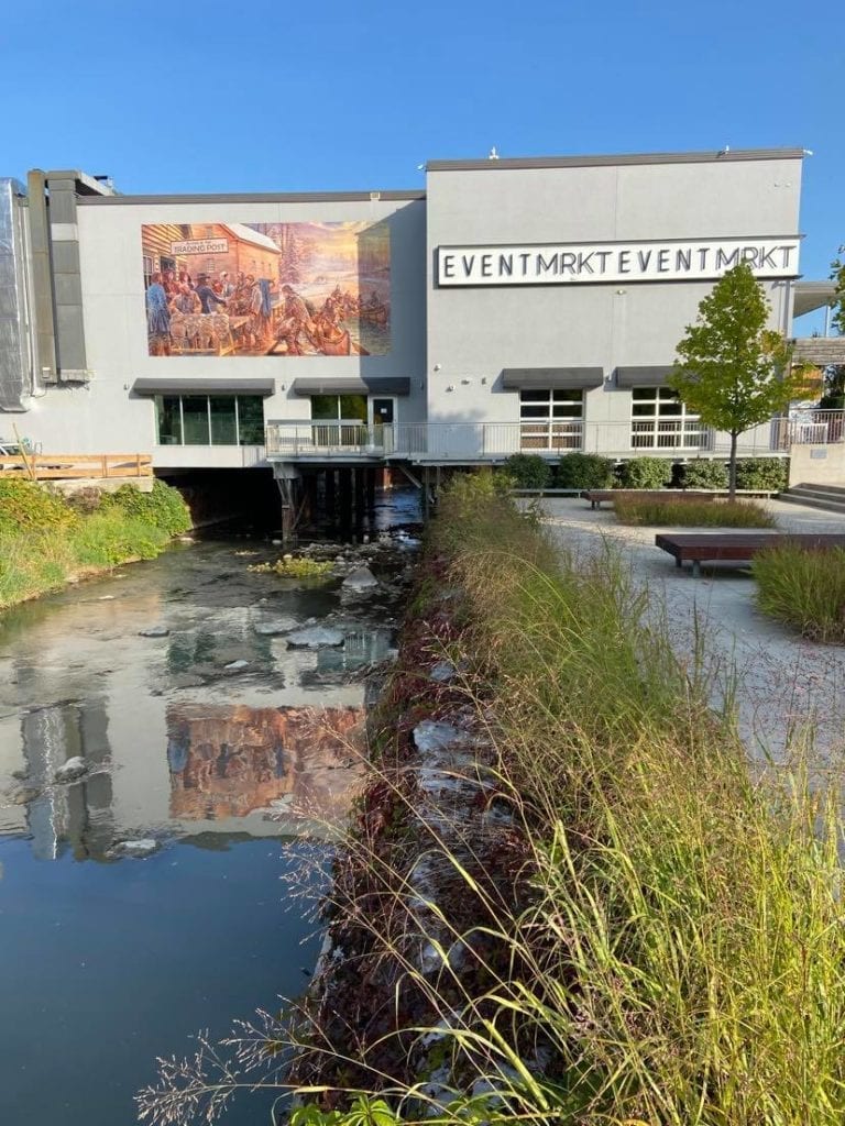
However, first thing I did was visit the location of the old Pullan’s Valu-Mart, because it marks the start of the river post-Fairy Lake.
There’s now a large artwork on the side of the building titled ‘A New Market on the Holland River,’ which was created by Toronto artist John Kuna.
From a new viewing point, you can see both the art and the actual location of the 1814 Roe & Borland Trading Post depicted in the mural before Newmarket was incorporated as a town.
The mural depicts two Chippewa families arriving at the trading post by the Holland River, the “New Market,” where they are greeted by members of the founding Quaker community.
In 1801, Timothy Rogers brought Quaker families from Vermont and Pennsylvania to begin settlement of what was then known as Upper Yonge Street. It then became Newmarket.
Kuna said, “This mural captures a moment in our collective history for all of us to learn from and to think about and to share. It is our hope that the residents and visitors to downtown will stop and take the time to view this mural and reflect on its meanings and to learn something that they may not have known before about Newmarket.”
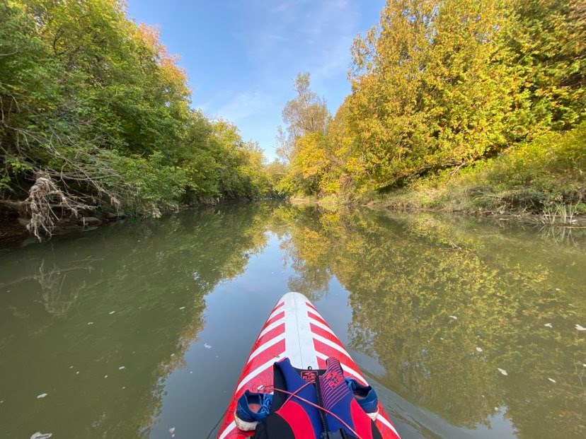
Paddleboarding the East Holland
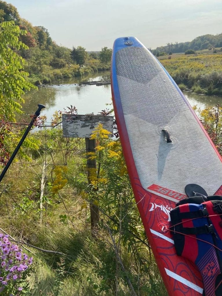
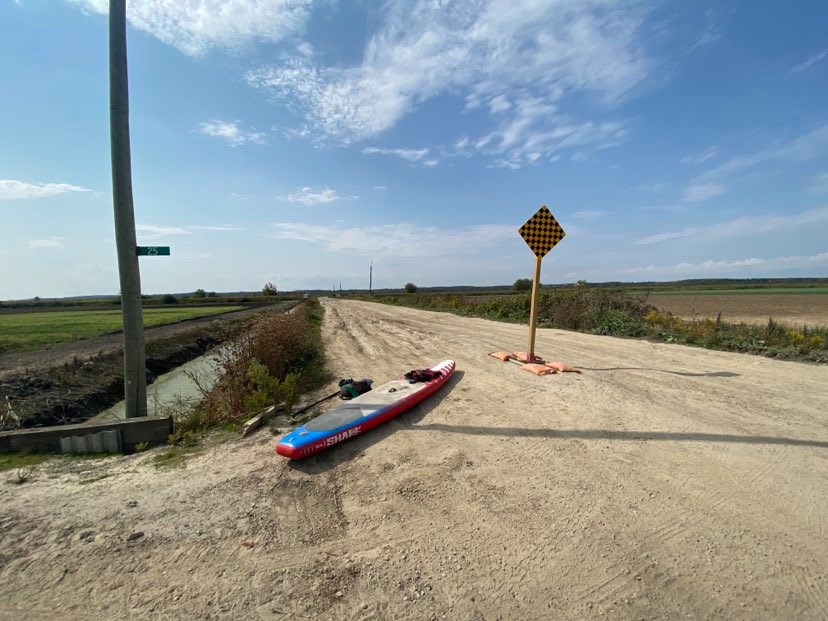
Rogers Reservoir: I parked next to Green Lane in a dirt lot near a driving range. In the 1980s, my family would park there for our weekly walks. We’d walk across the swing bridge and down a narraow path to an old fire tower.
It’s fall, so I knew the water would be low, not like it’s every really high. I had no idea if I could paddle the river because there are no trip reports online. On Google Earth, there were a few stretches that looked questionable, but if it got too bad, I could always walk to a road.
From Green Lane, I paddled north to Rogers Resevoir and the first lock. In many spots, the water was too shallow to paddle, so I had to step off the board to walk through ankle-deep levels over small rocky sections.
I avoided sunken tires and metal barrels. There was a lot of junk.
The trail was rebuilt in the 1990s and is now a popular out-and-back. The parking lot fills up on weekends and the fire tower is gone.
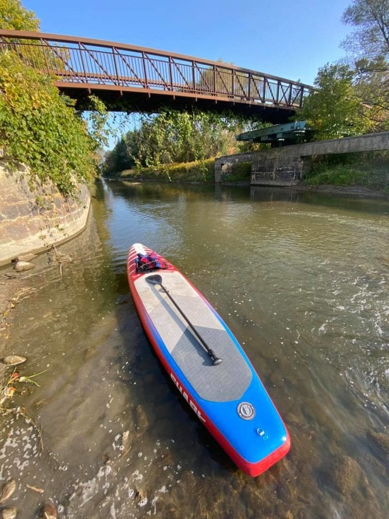
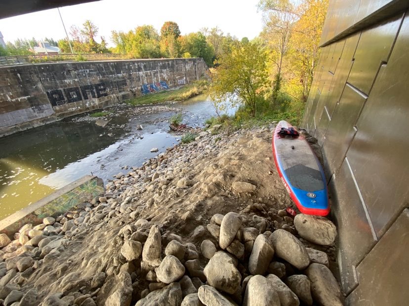
Nokiidaa Trail: I left the river before the lock at Rogers Reservoir to avoid a 20-foot drop. I found a steep bank with no signs of recent passage. I hauled the board up to dryland as onlookers watch with confusion.
I walked over the walkway and dropped to a rocky slope under Main Street North. I stumbled over loose stones to the river.
There was a car half-sunk with only its rusty front-end visible.
It was deeper than the above river. I paddled past dozens of people walking along the trail and north under leaning trees. Only a few shallow sections slowed me down. A naked person sunbathing on the shore said, “Is that how the kids are getting around these days?”
As I approached the next lock, I realized that both shorelines were steep and bushy and the tops were guarded with barb-wire fences. I escaped the river before the next 20-foot drop and climbed a steep slope.
People watched as I tried to up-and-over the wobbly-poled fence. It took a few minutes to find a place where I could pass without damaging the board or myself.
Bye, Bye River: From there, I walked through a parking lot and across Yonge Street. I couldn’t see a way back into the river after the lock. Thick bush and reeds blocked the water. I walked down Queen Street to a place with less foliage and whacked to the water.
On the map, this looked like the most difficult stretch. After a few hundred metres, the river braided into creeks that meander through dense forest.
I felt like the river didn’t want me there. I wresteled hard-to-budge branches and twisting vines with spiderwebs filling voids between trunks.
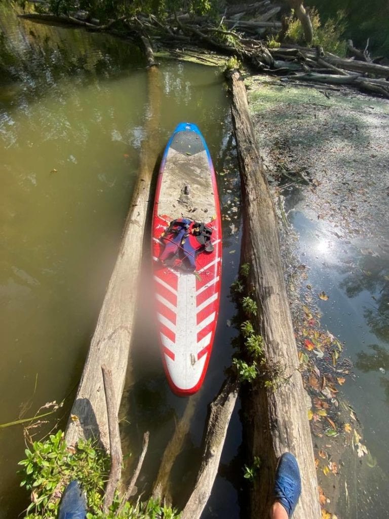
I crawled over maples spanning the creek and was forced off my board. This is when it became clear that few paddlers complete this stretch. It’s overgrown and littered with trash stuck against timber that’s washed downstream.
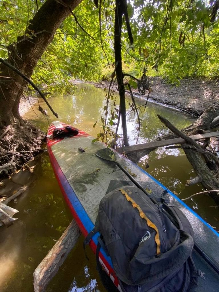
The creek was deep, I couldn’t touch the bottom with my paddle, but only three to six feet wide. It was weird. I slipped into the water and my feet only touched the bottom after I sunk up to my chest.
I knew this section would be complicated to navigate, but it was harder than I imagined. I used my paddle’s blade to slice a path into the tall plants.
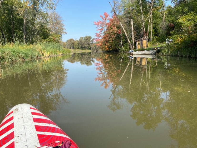
After Oriole Park, the river widened into marshy habitat under full canopies. I floated around gentle turns, thinking I’d run into more log jams, but then I saw an old boat house and soon a boat. I knew that I had made it through the shallows.

Sand Road: I checked the map to see where I was, only to spot that I was about to paddle past homes on Sand Road. My brother once lived on that road. It was a dark time in his life.
The water was murky, almost like chocolate milk. It was thick with floating lilly pads and blobs of algea. “Don’t touch the water,” I thought. I wouldn’t swin in it. The docks were lined all yellow, grey and sinister, hung with old ropes tied to half sunken tin boats.
If there’s a bylaw team in charge of maintaining shoreline esthetics, they get an F. Much of that derelict stretch of bank is at the end of unmaintained yards of the residences of Sand Road.
I passed by an elderly couple in a canoe; they were the only paddlers I saw. I said “hello” and they replied with “is that a surf board,” to which I said, “yes.”
I tried to take a selfie by placing my phone on the lifejacket. With every more, the phone tipped. I ended up with this weirdly cool shot.

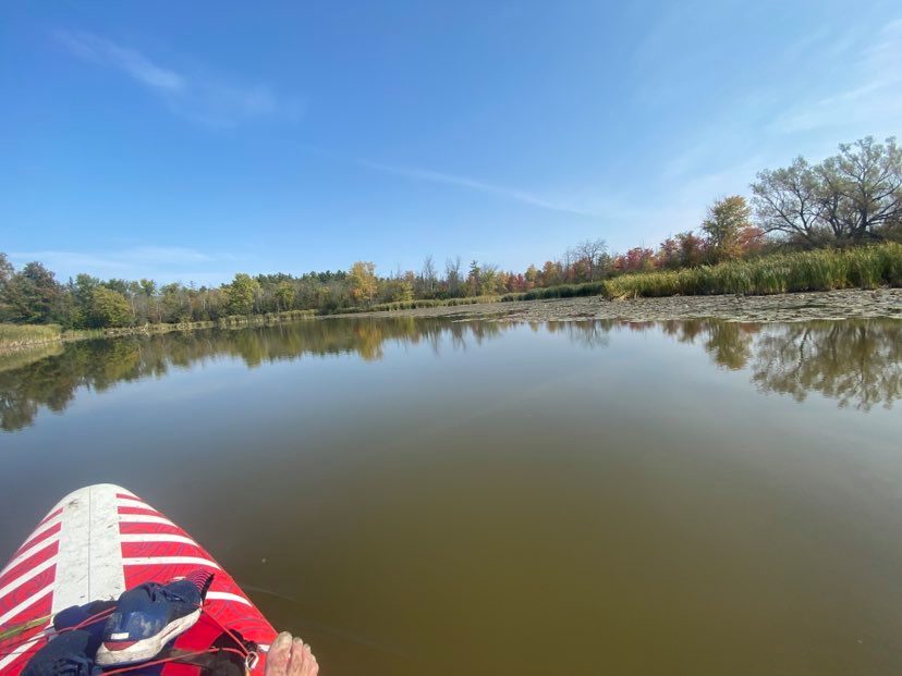
Albert’s Marina: I paddled beneath Queensville Side Road and through River Drive Park. The still water was only disturbed by my paddle, the herons and and American bitterns. The sun was high in a cloudless sky, and despite being late September, it felt like a mid-July one.
The river widened to over 100 metres and felt a lot bigger than where I started next to Green Lane. The trees thinned as the shore faded from forest to field.
I rounded a big turn and aimed for Albert’s Marina, a place I visited as a kid. I floated past the big ‘Gas’ sign and watched boat owners trailer their vessels for the season. One man, standing on the deck of his yacht, said “want a beer,” to which I said “yes.”
Not wanting to deviate into the marina, I stayed true and continued north sans-beer.
After the Holland River Marina, there wasn’t anywhere to leave the river until Ravenshoe Road. All buildings, roads and structures disappeared as I entered a grassland-esque geography.

Homestretch: I felt alone and committed, something I didn’t think I’d experience on the Holland. I remember being on that stretch as a kid, but we were in a boat that left a big wake.
Moving at 4 km/h on a floating piece of rubber allowed me to focus on every inch of the river in a way that I couldn’t in a motorboat.
The river was as wide as it would get, well over 150 metres, and the shoreline plants were tall and rushlike. A few birds circled above as I paddled to the junction of the East and West Holland rivers.
The sky and water started to feel as though they were about to become; only a strip of narrow land separated them. I felt slightly delusional, but it could have been the soaring temps and lack of drinkable water.
I once saw a photo of trees along the Serengeti River that made me want to visit. The trees along this stretch of the Holland reminded me of that photo.

I looked at the map and decided that I would end at Ravenshoe Road, because there were no easy exits on Lake Simcoe, and the wind was blowing against me.
At the junction of the East and West, I looked back to the historic point and prepared for the wake from a seadoo that was blasting past.
Five more boats, some with fishers and some with soon-to-be-wakeboarders motored north. They slowed and I waved to them as they waved back.
I paddled to a wooden dock, it was old and broken, next to a dusty field with dry corn stalks. I carried the board down a dirt road to where my ride was driving to. Big farm tractors worked the land.

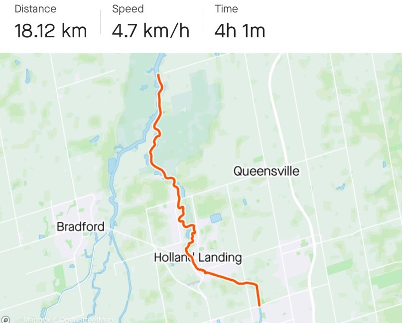
Summary-ish: I travelled 18.1 kilometres from Green Lane to Ravenshoe in four hours and one minute. It was a route used by locals thousands of years ago.
As I paddled, I imaged a wilder place with less concrete bridges spanning overhead. I thought of clearer water, more beavers, healthier fish and the smell of camp fires.
This was an important highway before freeways and doesn’t get the attention it deserves. Yes, some sections need work to make it safer, but I think it would be worth the effort to restore this historic trade route.
Who’s it For? Not everyone. It’s a burly paddle along a waterway with no current and shallow water. You couldn’t use a canoe or anything other than a paddleboard without a fin. Once you pass Queensville Side Road, you can add a fin.
Maybe in the spring during flood season with less bush along the shores would make for an easier trip, but I can only imagine how bad the bugs would be.
You need to beware of sunken metal and watch where you walk on shore. Not a trip for the whole family.
The Send: For me, this was an adventure-on-deck for decades. Paddling from Newmarket to Keswick along the Holland was one of the first “big” adventures I imagined as a kid, before my days as a climber.
I’m happy that I did it, because I won’t be doing it again anytime soon.
Other Adventures
Hiking Mount Harvey North of Vancouver
Animikii-wajiw “Mount McKay” in Thunder Bay
Hike, SUP and Fishing on Boom Lake
Hermit Meadows in Rogers Pass
Northwestern Ontario Paddle and Fish
Paddleboarding Historic Toronto-area River
Musky Fishing in Northwestern Ontario
Hiking the Lion’s Head Loop in Ontario
Ice skating Lake Louise and other mountain lakes
About Adventures with B: My late friend Anna Smith, who lost her life Himalayan climbing, once said to me after an epic we had in Chamonix, where we got away unscathed: “Adventures with B are messy and unplanned but always fun.” This column will focus on skiing, hiking, SUPing, paddling, fishing and other adventures. A new alpine climb in 2020 was named in Anna’s honour, read about it here.
Check out the latest buyer's guide: