Mount Lady MacDonald (Lady Mac) is a big mountain with a number of peaks, ridges and complex faces. It stands at 2,606 metres on the north side of the valley above Canmore in the Bow Valley.
In 2006, I took a helicopter over the mountain to look for winter routes. I thought I’d spotted an ice pillar, so a few days later I was joined by friends Noel Gingrich and Michelle Spakowski for the first ascent of Ghoster Coaster, a three pitch WI3 that now often has multiple parties a day. But we never found the ice pillar.
Fast forward to 2019 and my curiosity of whether there was an ice pillar high on the northeast or north face of Lady MacDonald had peaked. Joey Wallick and I went for a recon lap and could see the potential for big ice up high.
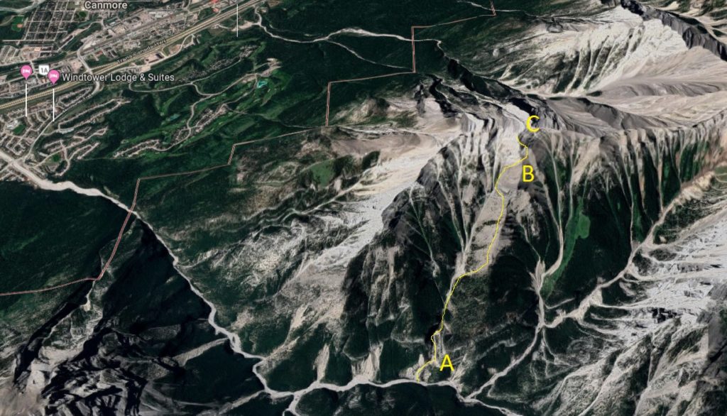
Back home, we took a look at Google Earth and found a few steep constrictions high above Ghoster Coaster that could hold ice. Thinking the wall was smaller than it was, we left Canmore at noon in mid-January with an alpine rack and headlamps.
After climbing Ghoster Coaster, which is an hour from the car, we started our mission up the gully above. There were hundreds of metres of broken ledges, ribs and trees to pass to reach the upper faces. The snow conditions on the southeast and east aspects was perfect to moving quickly.
However, there was no way to move quickly enough to climb the upper headwall and ridge with the sun up, as it was setting at 5:05. We knew we’d be climbing under the half moon with headlamps.
Beneath the 400-metre east face of Lady Mac were a number of options, but the compact limestone and small roofs meant finding a line of weakness that was protectable would be difficult. With temps dipping to -15°C, we knew we had to keep moving under the night sky.
Far below was a think blanket of ice fog that choked the valley, we wouldn’t see the lights of Canmore for many more hours.
Under the east face was a gully that took us to the steep northeast ridge, that was broken into sections of overhanging rock and low angle blocks. We roped up as the sun set and led across the top of a north-facing snow gully. Snow on the north aspects was much more prone to avalanche, so we protected the traverse and stayed close to the wall.
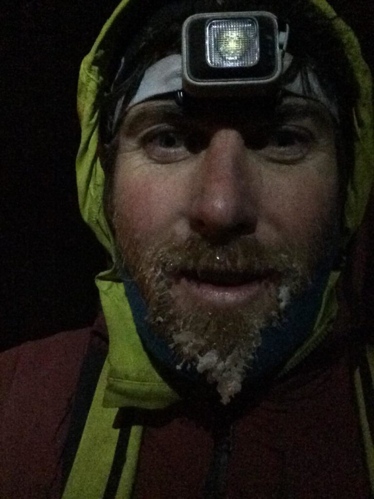
On the next pitch, I continued across to an M4 break in the rock that led me to a steep ledge where I belayed Joey off of my tool and a wonky cam. By now, the sun had completely set and we were climbing by moon light and headlamp. It was quiet and some of the ice fog and drifted up to us, which reflected our head lamp beams back onto our faces.
The climbing continued to be run-out on steep mixed terrain with deep faceted snow. From time to time, moss would be visible which would provide the most bomber sticks for our ice tools. Four pitches up, I found my way back from the north face to the ridge itself. I turned my head lamp off and sat, straddling the ridge as Joey followed. The corniced ridge drew a crisp line along the starry night. I wish our phone batteries hadn’t died from the cold temps, the views were amazing.
A few more pitches of steep snow tunneling and thin mixed climbing led us to the summit of Lady Mac. Unfortunately, Google Earth labelled the wrong peak with the summit marker and we were a kilometre north of the true summit on the rarely climbed north peak of the massif. It was 10 p.m. and the wind was picking up.
We descended the steep southwest face from the summit down an area few climbers have likely been. Ankle twisting scree and avalanche-prone slopes led us to a canyon. We made three rappels off dead trees and logs to reach the lower creek. We brought no food or water and our minds were drifting. Eventually we made it to the road, some two kilometres from the car. Our goal was to descent the hiking trail off Lady Mac, but our miscalculation by reaching the wrong peak meant everything wasn’t going to go to plan. We walked to the car and then ate pizza.
Mount Lady MacDonald is named after Lady Susan Agnes MacDonald, the wife of Canada’s first prime minister, John A. MacDonald. So we’ve decided to call the route: Agnes Ridge III M4 WI3.
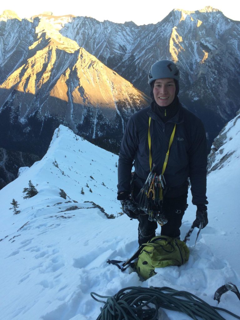
We brought one 60-metre rope, a few pitons and a rack to two inches. There wasn’t much gear on the route, except for at the anchors. I suggest leaving Canmore before noon as the climb took us 12 hours car to car.
Agnes Ridge
Approach: Up Cougar Creek to Ghoster Coaster. Climb Ghoster Coaster and scramble to the upper wall. Head right to the obvious arete/ridge and rope up.
P1: Traverse right along gully to safe spot on rib (55m)
P2: Continue right and then up through break to ledge (60m M4)
P3: Head up the steep rock and obvious line to block belay (60m M3)
P4: Move up and left to cracks/slops to ridge proper (60m M3)
P5: Traverse down and right away from buttress to rock next to gully (55m)
P6: Move right and into the gully, good rock on left up past a number of slopes (60m M3)
P7: Continue up the ridge to the summit of Lady Mac’s north peak (60m M2)