New Safer Descents for Aftonroe and Rundlehorn Rock Climbs
The goal is to reduce crowds at ascent/descent anchors during physical distancing protocols and to speed things up
The Canadian Rockies are busy this year with rock climbers, hikers, scramblers, trail runners, mountain bikers and more taking advantage of summer conditions.. The go-to entry-level multi-pitch bolted routes have seen a rise in popularity over the past few years.
Two of the most popular areas are Guides Rock and the North Ridge of Rundle, both close to the town of Banff. Aftonroe, one of Canada’s most popular 5.7 multi-pitch routes has a new rappel descent that will de-clutter the ascent route. On Rundle, the routes Rundlehorn 5.6, Sunriser 5.9, MacLab Slab 5.6 and Gold Rush 5.7 can now be descended via a walk-off, which avoids the often busy rappel lines down the ascent routes.
IFMGA climbing guide Shaun King has added information to the Mountain Conditions Report for Aftonroe here and Rundle here. We’ve copied the text below in the case you can’t open the links, both were written by King.
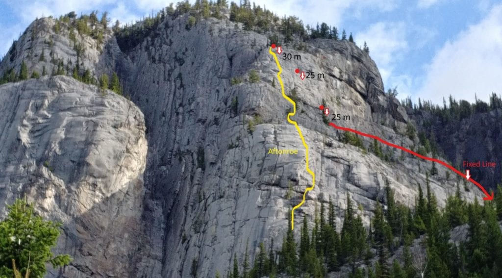
Aftonroe
Aftonroe on Guide’s Rock has deservedly been a hugely popular climb for some time now. Descending parties have always had to rap down over others climbing the route in the past. There is now a designated descent which is entirely separate from the main climb and is mainly a walk off.
From the top chains of Aftonroe, make three rappels (30 m, 25 m, 25 m) on the climber’s right side of the Aftonroe climb to a reach a good ledge. Note: you can bail from the top of pitch 5 on Aftonroe by traversing climber’s right on the same ledge but a large tree with long branches pushes you onto down sloping slabs with exposure.
Walk the ledge east (towards Banff townsite) sticking to the base of the steeper rock. There is a scuffed in trail with cairns and flagging marking where the trail zig zags down around a tree before heading east again to a fixed rope. The rope leads down a short step into a gully which is traversed to the far side (cairn). Follow cairns and flagging down the scuffed in trail until just above a main gravel filled gully. Instead of entering this gully which may funnel rock fall from others descending above, stay on the descender’s left, in and out of a smaller gully past more cairns until the main gully can be crossed lower down on a level trail which leads back west to the base of the climbs.
Rundle
The Rundlehorn climb sees a ton of traffic with multiple parties on every good weather day. With the addition of MacLab Slab, Gold Rush and Sunriser, there are a lot of folks out there and everyone is rappelling—either the route they climbed or the next one over. People rapping over each other slows everyone down, increases the risk of rockfall onto others and makes COVID distancing hard at shared stations. Additionally, most parties will take as long or longer to descend than to climb their route.
There is a walk-off option that involves a bit of scrambling and gains another 150 m of elevation but most folks will be able to descend this way in about an hour versus two to four hours of rappelling, and save all climbers a lot of grief and exposure to rockfall.
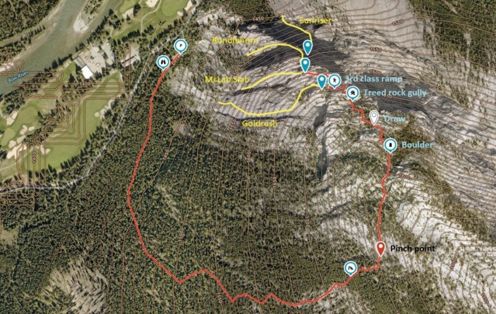
From the top of Rundlehorn, diagonal up and left, scrambling up some low angle rock to gain flatter terrain and follow cairns back right until below a sizable steep face. The Gold Rush climb finishes just below this face on climber’s right. Follow a 3rd class ramp (see photos) up and left across this face to break through to easier terrain above. Head back right following cairns that lead up to a steepish treed gully filled with slate-flat rocks embedded in the earth. Bypass this low on the right through trees to gain easier terrain above and eventually an obvious draw with gravel in it higher up. Immediately above the draw go hard right past trees to gain a rock rib that leads up to a flattish bench below the next big steep rock face. Locate a large boulder with a cairn on it, in a small clearing in the trees @ GR 02096932. This is the landmark to start traversing south. Start just beneath the steep rock and gradually diagonal down through spaced trees until rock slabs force you down through a pinch point between the slabs at GR 02076910. All grid refs are NAD 83.
After this, diagonal out descender’s left to where steep scree slopes lead down to short section of dead-fall. Diagonal out left again to link up more scree slopes which lead to lower angled open forest and eventually a trail system below 1450 m that leads north back to the packing lot. ~1 hr.
If you are climbing MacLab Slab or Gold Rush it is a good idea to walk SW from the parking lot on a trail for 40 m to a viewpoint (see photo) where the trees open up and you can see both climbs. If you can see a party already on your intended route, it is advisable to pick another objective as these climbs have a lot of loose rock.
Check out the latest buyer's guide: